German Maps (Topographische Karte 1:25,000)
Topographic 1:25,000 scale maps of pre-WWII Germany.
About the Collection
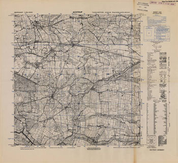
The library holds roughly 3,200 Germany maps at 1:25,000 scale. This set covers all of pre-WWII Germany, which now includes all of the Federal Republic as well as a good part of Poland. The majority of these maps are found in envelopes and filed in map file cabinets. A small number are filed flat in large map case drawers. This Germany set was obtained by the British right after the war, and later given to the U. S. Army. Even though some of the printing dates run into the 1950s, most of the data found on the maps is from the 1930s and 1940s.
The map sheets are laid out in a numbered grid pattern, running north to south and west to east, with the numbers increasing by 100 with each succeeding row. Example:
| 1928 | 1929 | 1930 | 1931 |
| 2028 | 2029 | 2030 | 2031 |
| 2128 | 2129 | 2130 | 2131 |
Circulation
These Germany maps do not circulate. But digital copies are easily made, as well as paper scans.
How to Use the Collection
Determining which sheet number you want to view is done by accessing a four-volume Cold-War-era gazetteer on the Internet Archive. There is one volume for the gazetteer to AMS 1:25,000 maps of East Germany and three volumes for the gazetteer to AMS 1:25,000 maps of West Germany.
- Volume 1: West Germany, A.D.Affenberg to Haszfelden
- Volume 2: West Germany, Hateler-B. to Ozental
- Volume 3: West Germany, P Kerhof to 100 Morgen
- Volume 4: East Germany
Paging through these four volumes, you’ll be able to search innumerable place names throughout all of Germany. Keep in mind that if you don’t know whether your location is in the East or the West, you might have to search in more than one volume.
- In the gazetteer, find the sheet number for the place name you are interested in.
- Go to the Germany Maps collection search page.
- Type the sheet number in the search box, click Search, and then double-click on the map thumbnail. Your map will appear. Printing and downloading options are available.
If you prefer to look at the paper maps, come to the library with your sheet numbers in hand, and we’ll be more than happy to help you find the physical maps you need.